Saturday, July 27, 2013

A Day out to Glen Davis

On all our travels to and from Turon Gates, we always passed the sign to Glen Davis at Capertee and always said "we should do that soon". Finally we did. We always knew how beautiful the Capertee Valley was by that wonderful view that can be seen on the Mudgee Road. Besides it's the second largest canyon in the world, the first being the Grand Canyon.

Glen Davis was a town built in 1932 for the oil shale industry, just like Newnes on the other side of the Wolgan Valley. Once the oil shale mine closed in 1952, basically so did the town. A lot of buildings still stand but not really historical. The main historical factor is of course the old mine but that is closed up and only available to look at at certain times. I found out later that tours run Saturday afternoons at a cost. We wondered if the ruins were fenced due to them now being unsafe or was it a way to make money - who knows.

The only movement in town was at the free campsite almost in the middle. It offered showers & toilets (give me my camp potty and camp shower any day). The occupants were mainly caravans and their grey nomads with their little dogs!!!!

Unfortunately I did not get a good feel for Glen Davis. Don't know why.

Upon leaving town there was a turn-off on your right to Wollemi National Park. The black dragon instantly needed to turn and check it out. It was a good road, except for the pot holes, but even a sedan would have had no trouble. Surprisingly this was a great way to see the ruins (on the other side of the fence of course) and lead to an open campground. This would have been our choice to stay at instead of the middle of town. We took a walk on top of a hill to check it out and to our surprise got a view of the ruins again from above. This at least made our trip to Glen Davis worth it.

Glen Davis Oil Shale Ruins
I am glad that we have now visited Glen Davis and can mark it off the list. It was a wonderful day out with the family, the valley just lovely and a drive that continued on to Dunns Swamp for lunch. I choose a day like this any day, no matter where the road takes us or the feeling I get, good or bad.

Until again...

Abercrombie River National Park

Really, how lucky are we all that we have the internet as a tool these days. I remember having to rush to the library to borrow the one and only book that related to the project that you had just been given. Now we have all the information needed right in our own home...

Which leads me to acknowledge the amount of information available to us on the net relating to 4WDing, camping and all the rest of it. It was while doing research about Abercrombie River National Park that I first realised that your visit should avoid the winter months. Upon finding a video on You Tube that a past visitor had uploaded, it revealed that today it was sunny and tomorrow it snowed or more seriously today it was sunny, during the night it rained, and tomorrow the creeks were up and you couldn't cross them!

All this aside, the National Park is a wonderful place for 4WDers to visit. A sedan would not cope at all as the roads in places are quite rough and very steep. 


Photos never seem to show the actual steepness
We took a day trip to initially check out the park but knew by the end of the day that we would go back for a camp out. Unfortunately it would be back to the tent set up with stretchers (for us anyway - the boys still would suffer the ground) as we would not have got our Swan in there, happily anyway. That would be during the month of March. Great time - pleasant days and nights.

The Park basically has a main track that circles right round. There are a few roads that veer off but they eventually all meet up on the main one. There are creek crossings and lovely views to see. Off this road are the entrances to the campgrounds. These include The Beach, Silent Creek and The Sink. Silent Creek is our favourite as it is on shady grassed river flats however The Beach is great for swimming and The Sink would be great for the kids to go exploring. Always good to be in the know, there are pit toilets at all the campgrounds.


The Beach


Silent Creek

The Sink

The creek crossings are just lovely and easy done - however after rain I'm not so sure! Along the creek beds are definitely opportunities for lovely photos.


Of course, if you know me well, there was also another positive for our trip to the Park. We stumbled across old dwellings as part of the Park's history. Certainly a tick of approval.


Abercrombie River National Park is definitely a place you should visit. It's peaceful, picturesque and priceless! 

Until again...

Monday, February 18, 2013

Mt Irvine Road

Sunday, 17 February 2013

It was about time that we went on another drive. Unfortunately our adventures lately have been few and far between. D hadn't even had the opportunity to show what his new Bridgestones could do!

Quite a while back my father told D of a drive that he had taken in his V-Dub many many moons ago that went from Bilpin to Mt Irvine. Clearly this road at the time was in good condition as my father was and still is very car proud and treats them with great respect. Today, being an older and wiser man, he won't even drive his beloved Holden on dirt. So surely this meant that we were in for a very pleasant drive. We would start at the Bilpin end off Bell's Line of Road.

Well all I can say is that my father would not have even passed the open gate and, as we saw, even a Mitsubishi AWD reversed out. As she passed by she said "not with my tyres". She certainly was not wrong!

Mt Irvine Road or also known as Bowen Creek's Road was opened in 1935 to provide a through road from Mount Irvine to Bell's Line of Road and shorter route to Kurrajong and the rail head at Richmond. The access road generally followed the packhorse track marked out by C R Scrivener in 1899. It was constructed during the Great Depression with unemployment relief funding .


The Opening of the Bridge in 1935

A few thoughts were going through our heads during the first part of the drive. Firstly there was a sign at the start of the road that indicated it was closed. Secondly the lady in the AWD was uncertain if the bridge across Bowen Creek was still standing. However we assumed (some say you should never assume) that surely if the bridge was closed they would have closed the gate.

In parts the road was very rough and washed out. The black dragon was moving at walking pace. In many sections our son and I had to guide D. The road was also extremely narrow in parts and at other times extremely steep. It was definitely not for the faint hearted and definitely high clearance and low range was required. There were no places to turn around and go back if you felt that you didn't want to go on.


The road as it once was


The state of the road in places today


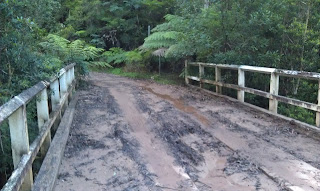
Upon arriving at the bridge our first thoughts were of relief because the bridge was in tact. At the time a trio of bike riders had arrived on the other side. The bridge had also been closed with orange mesh blocking each end. This had been taken down so access to the bridge was possible (clearly by other 4WDers or bike riders). When I heard one of the bike riders say to D "you won't get the car across" I must say I nearly had a heart attack. I am an avid McLeod's Daughters fan and had just finished watching the episode where Claire went over the edge of a cliff in her 4WD and died!!!!!!!!!

We watched the bike riders proceed across safely and then it was our turn. D had assured me that the bridge would not give out. Besides, he said, the Gall Boys had gone across much worse bridges on the Telegraph Track and they were pulling a caravan!!!!! I must say I was still sh***ing myself but, of course, made it across safely having not taken one breath through the ordeal. D then proceeded to tell me that the conversation also revealed that the Council was about to demolish the bridge due to its danger to the public!!!!! He also told me of the missing pieces in the bridge. Sometimes maybe things are best left unsaid, or in our case, delayed in revealing!


As the bridge once looked like!
The bridge today

Does this mean that we were the last 4WD to cross the Bowen's Creek bridge? 

The road beyond the bridge to Mt Irvine was a piece of cake. We were told that the road was in a good state so that the Council could bring in the relevant machinery to demolish the bridge.

All in all the drive was enjoyable even though I was nervous at times. If this road is going to come to an end, we are very happy that we experienced this adventure. What is it about our family. We did the Bridle Track a few years ago and soon after a landslide occurred so the road is no longer a through road.

On a final note, the moral of the story is that you should always give something a go in a safe and sensible manner. Besides you need a bit of hard core once in a while to see what your beloved 4WD is actually capable of!

Until again.....